On Earth there are many hotspots which are characterized by topographic swell, higher temperature, and recent volcanism with isotopic signatures distinct from those that characterize mid-ocean ridge or andesitic basalts. Of all the hotspots, Hawaii is a well-known example. Although many geochemical, geophysical and seismological studies have suggested that the Hawaiian mantle plume originates from the core-mantle boundary (CMB), so far no tomographic model shows a continuous image of the Hawaiian plume in the entire mantle because of the few seismic stations on the narrow Hawaiian island chain (Fig. 1).
Recently we determined a new tomographic image beneath Hawaii by applying the updated global tomographic method of Zhao (2001, 2004) to about 1.2 million arrival time data (Lei and Zhao, 2005). This data set includes ten kinds of seismic phases, P, pP, PP, PcP, Pdiff, PKPab, PKPbc, PKiKP, PKKPab and PKKPbc, which are extracted from the International Seismological Center spanning the years 1964-2004. Of these phases, PKiKP, PKKPab and PKKPbc are, for the first time, used in the global seismic tomography. This new model shows a slow anomaly beneath Hawaii ascending continuously from the CMB to the surface (Fig. 2), implying that the Hawaiian plume indeed originates from the CMB. This image is improved notably over the previous results in the whole mantle, particularly in and below the middle mantle, suggesting that later phases, PP, Pdiff, PKP, and particularly PKiKP, are of great importance for better imaging the Hawaiian plume. This slow anomaly is considered to be a plume conduit being tilted, which is likely caused by the mantle flow. This indicates that the position of the Hawaiian hotspot on the surface is not stationary, as evidenced by the recent paleomagnetic and numerical modeling studies. (Jianshe Lei and Dapeng Zhao)
References:
Lei, J., Zhao, D. (2005) Earth Planet. Sci. Lett. (in press).
Zhao, D. (2001) Earth Planet. Sci. Lett. 192, 251-265.
Zhao, D. (2004) Phys. Earth Planet. Inter. 146, 3-34.
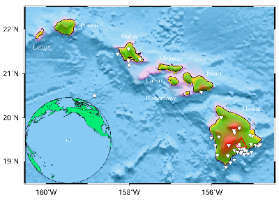
Figure 1: Topography around the Hawaiian island
chain in the Pacific Ocean.
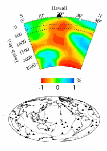
Figure 2: P-wave tomographic images along the
north-south vertical cross-section
passing through the Hawaiian hotspot.